Archaeological Survey: Methods and Preliminary Results
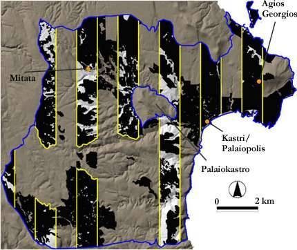
KIP survey area (blue outline): tractwalked areas in black;
transect sample in yellow outline (and shaded light grey where inaccessible).
Archaeological fieldwork has centred on four seasons of intensive survey (1998-2001), concentrating on the central-eastern region of Kythera and covering a spectrum of landscapes from coastlands through to interior plateaux. The KIP survey area covers 100sq.km of the island (ca. 36%), including the hinterland of the multi-period port at Kastri. Two internal zones - the Classical-Roman polis on Palaiokastro mountain and the excavation area of the Agios Georgios peak sanctuary - were excluded because they are being investigated by other researchers.
Within the KIP survey area, 43sq.km (ca.15% of the island) was intensively surveyed in sub-hectare tracts (over 8,700 in total; median tract size = 0.4ha) by walkers spaced 15m apart. Tract-walking was designed to i) sample the survey area in regular, 1km wide, north-south transects (to explore a variety of cultural and environmental locales), and ii) cover regions of special interest continuously (such as coastline and well-preserved or agriculturally favoured areas of the interior).
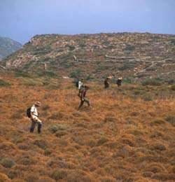
Line-walking at 15m spacing. Photography by C. Broodbank 2001.
Tract size and shape were defined arbitrarily in undivided terrain of similar visibility/vegetation or, where appropriate, followed local land use or cultural units. Surveyors worked in teams of 4-7 (typically 5) and recorded pottery counts, lithics, metallurgical debris and distance walked individually (walker recording form). Diagnostic pottery, lithics and metallurgical debris were then collected for further study. Additional information was recorded for each tract including ground surface visibility, land use and vegetation, standing and rock-cut features (tract recording form). A narrative account of daily fieldwork was kept in a team logbook (sample logbook page).
As in most other Mediterranean surveys, KIP retains the concept of the site as a short-hand term for concentrated activity (most often settlement), but also looks beyond this label to assess such things as site preservation, function, duration and scale in greater detail wherever possible. Site definition in the field was a multi-stage process, moving through i) identification during tract-walking, ii) initial revisitation, iii) geoarchaeological investigation and iv) site-based collection. Most sites have been characterised using a combination of at least three of the above, but the final assessment is made only after full study of the collected material in the finds laboratory, and therefore in many cases is still on-going.
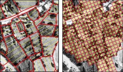
Kastri explored by tractwalking (left; ca.15m spacing walker lines in yellow) and then by 10x10m gridded collection (right; 5sq.m vacuum circles in yellow).
Site-scale surface survey is an increasingly popular strategy in the Mediterranean, and it is implemented on KIP as a standard second-stage method (site recording form). A few KIP sites were re-surveyed at greater resolution using line-walking techniques (e.g. 10m spaced 'mini-tracting') or grab samples (mapped for shape and location), but the great majority were gridded in 5x5, 10x10, or 20x20m squares (square recording form). Ground surface visibility and land use were recorded within each square and a circular 5sq.m sample was completely vacuumed for cultural material (over a 5 minute period).
In addition, a total count (of artefacts by type) for the square was made and further diagnostics were collected. This provides excellent collections with good intra-site spatial resolution for further study. Subsequent macroscopic and petrographic analysis of the collected artefacts continues to produce fresh insights, allowing us to return to studied material from new perspectives, and advertises the importance of acquiring permanent, statistically meaningful study collections.
Using such methods, KIP was able to document and analyse just under 200 archaeological sites distributed throughout the survey area (site distribution map). The major phases encountered are the Early Bronze II period (ca.2700-2200 BC), Second Palace period (Minoan Neopalatial, ca.1650-1450 BC), Classical (ca.500-323 BC), Late Roman (ca.300-625 AD) and Late Venetian to Recent (ca.1600 AD-present) periods (chart of sites by period). These peaks contrast dramatically with phases of retraction or abandonment. Preliminary tract maps of ceramics and of ground surface visibility offer a useful impression of the overall archaeological landscape and of one major factor affecting its distribution.
Further information about specific KIP research areas is available by exploring,
http://www.ucl.ac.uk/kip/index.php