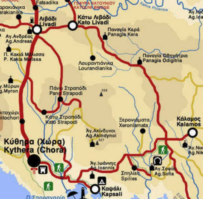
Map, showing clearly the turnoff down to Lourandianika.
(Top, upper, centre of the map)
Also showing that the road ends at the village, so that the village is located at a cul-de-sac or dead end.
Also the relationship of Lourandianka to Kato Livathi, Livathi, Kalamos, Hora & Kapsali.
The map has been added here in response to a plea in the Sept 2008 Newsletter, from Maria (Marcellos) Whyte.
Maria's email here
"I respectfully ask for any assistance my fellow Kytherians may be able to give me, as a tribute to my family, not to allow Louradianika be forgotten. I have no photos, only memories which are as vivid today, as they were when I was a girl of 15, but I would like to share this village of happy memories with my fellow Kytherians".
There is only one entry road to the village of Lourandianika, because about 50 metres past the small church of Ayios Yeoryi the road ends.
Although it is not clear from the road sign photographs, the road runs off to Lourandianika on an angle at the signpost, (and not on the same plane as Firi Ammos and Kalamos).
View of the signpost from behind and above, towards Kato Livathi
Map showing clearly the turnoff down to Lourandianika
The church of Ayios Yeoryi is small, but extremely well maintained. I had not read the Newsletter at the time I visited, so I did not not look carefully for, or at, the gravesites around the church.
Church of Ayios Yeoryios, Lourandianika. View Facing North
Church of Ayios Yeoryios, Lourandianika. View Facing South
Church of Ayios Yeoryios, Lourandianika. View across the rooftop at sunset
Cousin Theo Poulos and I were stunned by the quality of the fully sealed tarred road that leads to this cul-de-sac. If every road on the island was sealed to this quality, then.....
There are about 5 houses in the village. We met the elderly residents who live in the last well maintained traditional cottage.
House at the end of the road in Lourandianika
Elderly male. Lourandianika. 2008
The elderly lady declined to be photographed.
Frontage of the last house on the road to Lourandianika
Ruined House. Towards the end of the road leading to Lourandianika
Looking into the ruined house, Lourandianika
Stable wall at sunset. Lourandianika, 2008
The second last house on the left as you drive to the Church is quite large, modern, and extremely well maintained. Unfortunately by the time we went to photograph it, the night had set it, and our photographs did not develop properly.
The village of Lourandianika gave us the impression of our own village, Karavas - an idyllic setting, far from noise, cares, and woes. A little world unto itself.
See more photographs of Lourandianika at:
http://picasaweb.google.gr/Maxine195/LOURANDIANIKA2008_11_0202?authkey=LXqkcJvLb2Q#
